


Bird’s-Eye View: Photography of Real Estate Masterwork Series
A common “What if?” scenario that we’ve all been asked is: if your home were on fire and you could only grab one item (assuming family and pets were safe), what would it be? Some people might say a treasured heirloom. Others would say their phone or their laptop. Many others would say a scrapbook, a photo album, or a flash drive. The common thread? Wanting to preserve something important or special—especially when it comes to people, places, or events.
For that reason alone, photos play an extremely important part in our lives, as they have for centuries. Before the nineteenth century, however, likenesses were mostly captured through the painstaking process of posing for paintings. That all changed when Frenchman Joseph Nicéphore Niépce took the first photograph in 1826, a snapshot of his back yard. The first selfie? A Philadelphian named Robert Cornelius, who enjoyed tinkering in science and photography, became the first person to use himself as his own subject in 1839.
One industry that has truly taken advantage of this tool is real estate, particularly real estate developers. Think of your favorite mall, entertainment complex, or business complex. There’s a good chance its development was documented with aerial photography. It’s the first step of a process that leads to what can be a years-long project, and it can also help to chronicle the evolution of the complex over the years.
But photography reached new heights—literally and figuratively—in the mid-1800s with the advent of aerial photography. The first known attempt at capturing a bird’s-eye view occurred in 1858, when a French photographer named Nadar hopped into a hot-air balloon with his camera to take an aerial view of French sewers; unfortunately, the photos didn’t survive because of chemical reactions within the balloon. James Wallace Black snapped the oldest known aerial photo still in existence two years later in Boston. Other subsequent means to get such images include attaching cameras to homing pigeons and kites.
Since that time, aerial photography has been a vital tool across the globe—especially once planes were invented.
Wilbur Wright—who took meticulous photos of his and his brother’s attempt to be the first humans to fly teamed with L. P. Bonvillain in France to take the first aerial photographs from a plane in 1908; Wright piloted the plane while Bonvillain took the photos. Soon after, aerial photography was used as a tactical tool in both World War I and World War II, as US planes documented enemy locations. In addition, in the 1920s and 1930s, photography pioneers in the business also started using it for surveying and mapping purposes. In a very real sense, these photographers were chronicling history—only from thousands of feet in the air.
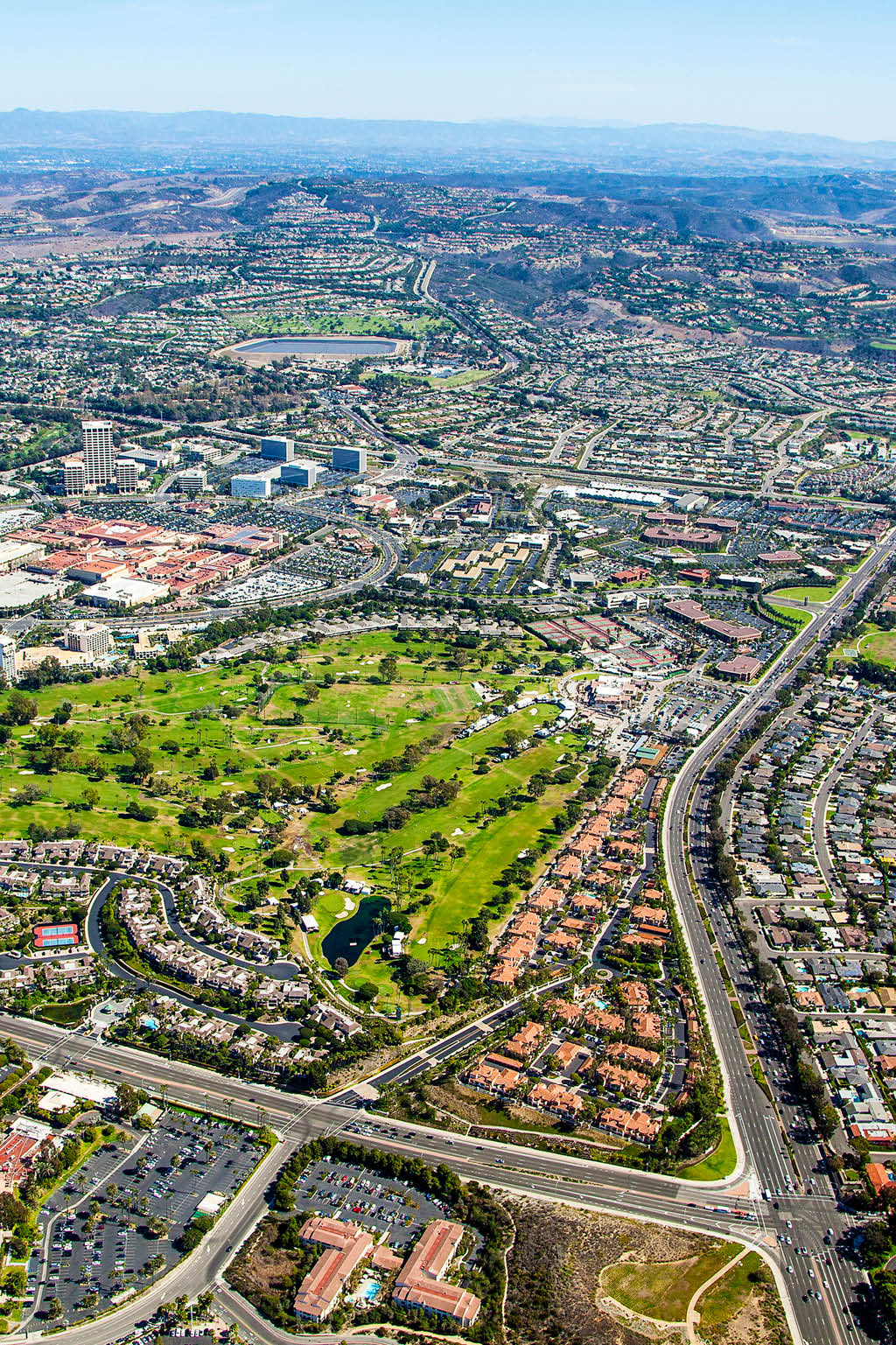
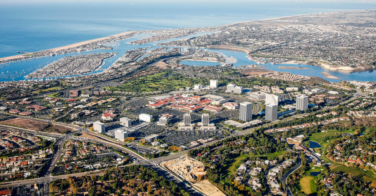
As such, these pioneers were also creating a unique type of photographic art. Fred Emmert and Richard Frost dub such photos “masterworks” in their new book series, Real Estate Masterwork Series Half Century Aerial Photography Retrospective, which celebrates the art of real estate development through historical aerial photography. One such example of these iconic complexes is the massive Newport Center/Fashion Island development, the first masterwork featured in the Real Estate Masterwork Series.
Set on ninety-three acres and located right off the Pacific Coast Highway in beautiful Newport Beach, California, this business, entertainment, and shopping complex features an upscale open-air shopping center that includes high- end department stores and over thirty restaurants in the heart of the complex— all with a spectacular view of the Pacific Ocean.
And it all began with the Boy Scouts.
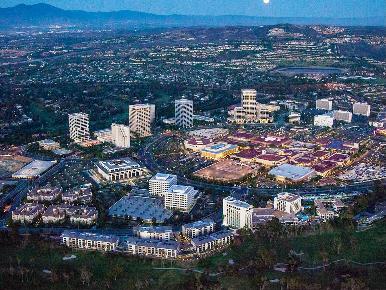
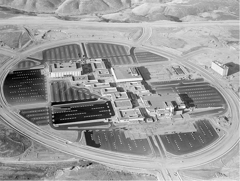
The plot of land that would become Newport Center/Fashion Island was part of the 93,000-acre Irvine Ranch, first developed in 1953 to host the International Boy Scout Jamboree. After the success of that event (featuring over 50,000 scouts and Vice President Richard Nixon), planning of Newport Center/Fashion Island began. The Irvine Company commenced with design studies in 1956, and it started planning and designing Newport Center in 1961. By 1966, ground was being broken on Fashion Island (first known as Newport Town Center), which opened a year later, in September of 1967, with four department stores as its cornerstones. (As it grew in popularity, it grew in grandeur: for decades the complex was also renowned for having the largest Christmas tree in America.) Since then, both Newport Center and Fashion Island have transformed, with the former adding several businesses, including The Irvine Company headquarters; and the latter having gone through several renovations—including a three-year, $100 million facelift starting in 2009.
All of this progress was documented from the very beginning, thanks to over a half-century of aerial photographs, which the authors call a “chronological time machine of an untold story.” Seeing the mixture of black-and-white and color photos—from the bare land of 1953 to the construction commencing in the mid-1960s to the buildings being added to the spectacular shots through 2015 (including a shot that Frost says is “one of the most beautiful pictures of Newport Center/Fashion Island I have ever seen!”)—is like watching history come alive.
That’s why, in a world that’s becoming accustomed to GoPro videos, virtual reality, and drone footage, such aerial photography is to be cherished, as Fred Emmert and Richard Frost are doing with their collection. These aerial photographs of Newport Center/Fashion Island immortalize the achievements of the past, giving us a visual pushpin of each advancement along the way and allowing us to see how innovation and daring to dream take flight.
For more info, visit realestatemasterworkphotos.com